
What the proposal says
We know that it can be difficult to find the time to read and to make sense or long documents. That’s why we’ve done the hard work for you.
This summary is intended to be a neutral and unbiased interpretation of the contents of the Draft Ferny Hills Precinct Planning Future Directions Report.
Key documents
1. Purpose and scope
The Draft Ferny Hills Precinct Planning Future Directions Report outlines a framework to guide future development in selected parts of Ferny Hills.
Its focus is on land use, built form, movement networks, environmental interfaces, and potential Planning Scheme changes.
It responds to regional population and housing requirements established by ShapingSEQ 2023.
2. Planning context
The City of Moreton Bay is expected to experience significant population growth.
State planning policies require increased housing supply and diversity, particularly in areas with existing services, transport, and infrastructure.
Ferny Hills has been identified as an area with conditions suitable for accommodating additional housing forms.
3. Existing conditions
The project area includes established residential neighbourhoods, local shops, parks, schools, and access to Ferny Grove train station.
Natural assets include Kedron Brook and surrounding bushland.
The area contains a mix of housing types but is predominantly low-density detached housing.
4. Community input
Between 19 May and 16 June 2025, Moreton Bay Council invited the community to tell them what makes Ferny Hills special via a pin map and vision wall. They also held a pop-up at the Hills Carnivale to hear from community members wishing to share their views in person.
Community members identified green space, tree cover, proximity to services, access to public transport, safety, and walkability as valued characteristics.
Feedback also noted concerns about traffic congestion, school access, bus frequency, and the condition or role of neighbourhood shopping strips.
A majority of survey participants preferred concentrating new development within existing urban areas rather than expanding into rural or natural areas.
Council considers this engagement the first phase of consultation for this planning proposal.
A summary of what people heard can be found in Engagement Summary No.1
5. Vision for Ferny Hills
The report defines an intended future state in which residential areas retain strong connections to natural features.
Housing supply becomes more varied in dwelling type and location.
Active transport and local movement networks are improved to better connect key destinations.
Public spaces and neighbourhood centres function as focal points for everyday activity.
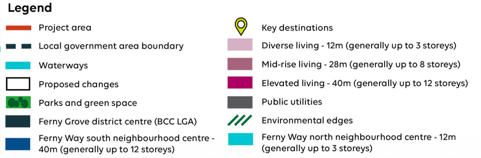
6. Types of housing proposed
The report identifies several housing categories and where they may apply:
Detached living: Low-rise detached houses; existing areas outside the project boundary remain unchanged.
Diverse living: Low-rise, mixed housing types; minimum 25 dwellings/ha proposed in some locations.
Mid-rise living: Medium-rise apartments (generally up to 8 storeys); minimum 100 dwellings/ha near transport and activity nodes.
Elevated living: Higher-rise apartments (generally up to 12 storeys); minimum 150 dwellings/ha near the Ferny Grove train station.
Centre living: Mixed-use buildings within neighbourhood centres, with heights aligned to surrounding zones.
7. Spatial changes proposed
Rezoning is recommended in several parts of the project area to facilitate higher-density or more diverse housing.
Neighbourhood centres on Ferny Way are identified for different building heights and density settings depending on location (north vs south of the road).
Specific lots (e.g., 20 Mawarra Crescent, 146 Ferny Way, 144 Samford Road) are identified for particular design or zoning outcomes.
8. Environmental considerations
Properties adjacent to Kedron Brook are designated as “environmental edges,” requiring tailored design responses to address environmental sensitivities and minimise edge effects.
Measures such as increased setbacks, use of native vegetation, and reduced light spill are listed as potential design tools.
9. Movement and transport
The report identifies the need for improved walking and cycling connections between key destinations including Ferny Grove Station, Ferny Hills State School, and George Willmore Park.
Some locations require design responses to improve pedestrian safety and street activation.
Potential adjustments to local street layouts may be needed to support future residential densities.
10. Car parking and built form controls
Reduced and “unbundled” parking rates are proposed for higher-density housing areas near public transport. Unbundled parking allows residents to choose whether they want to pay for a parking space rather than having the cost built into every dwelling by default.
Built form requirements include rooftop design standards, screening of podium-level parking, increased setbacks, and streetscape considerations.
Lot fragmentation is discouraged in areas intended for higher-density development.
11. Planning scheme implementation
Recommendations in the report would require future amendments to the Planning Scheme.
Planning scheme updates follow statutory processes and may be staged or adjusted depending on other concurrent work (e.g. biodiversity planning, natural hazard assessments).
12. Related ongoing council work
Natural hazard risk assessments (landslide, bushfire, flood) are underway and may influence recommendations.
A Biodiversity Plan is being prepared and may also lead to changes in long-term planning settings.
Next steps
We’ve looked at the Draft Ferny Hills Precinct Planning Future Directions Report and the ShapingSEQ: South East Queensland Regional Plan 2023 to understand the next steps.
We understand that Council’s next steps are:
Refine and finalise the Future Directions Report following this consultation period
Complete the contemporary natural hazard risk assessments and the Biodiversity Plan which may require changes to the final Future Directions Report.
Initiate planning scheme amendments or changes to enable the planned changes.
Seek approval from the Queensland Department of Planning for the planning scheme changes.
The new development zones
Did you know?
The City of Moreton Bay Council has proposed a similar development plan for Arana Hills.